Tropical Storms Rage Across Two Distant Oceans, Captivating Global Attention
 Layla Al Mansoori
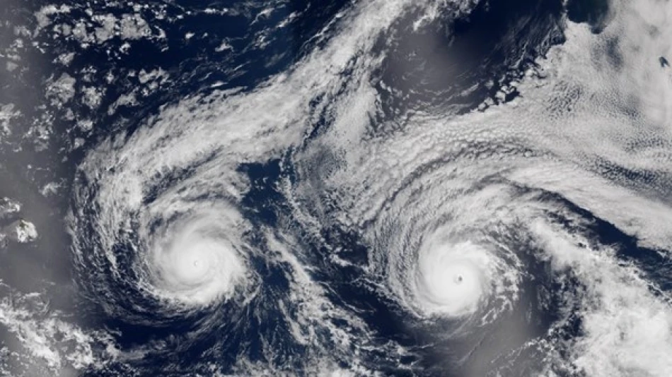
Twin Tropical Storms Juliet and Fernand Pose No Immediate Coastal Threat
Two tropical storms emerged simultaneously on Tuesday over open ocean waters, with Juliet brewing in the Pacific and Fernand developing in the Atlantic. While both systems are being closely monitored, meteorologists confirm neither poses an immediate threat to populated coastal areas, offering a brief respite during what has been an active hurricane season.
Pacific Storm Juliet Eyes Brief Hurricane Status
Tropical Storm Juliet is currently positioned 804 kilometers west-southwest of the southern tip of Mexico's Baja California Peninsula, packing maximum sustained winds of 113 kilometers per hour. The storm is tracking northwest at 16 kilometers per hour, maintaining its course over open Pacific waters.
The National Hurricane Center in Miami projects that Juliet may briefly intensify to hurricane status on Tuesday before weakening on Wednesday. This rapid intensification followed by quick dissipation is typical of Pacific storms that encounter cooler water temperatures and increased wind shear as they move away from tropical latitudes.
Geographic Positioning Offers Natural Protection
Juliet's current trajectory takes it away from major population centers along Mexico's Pacific coast. The storm's position southwest of Baja California means it will likely continue moving into cooler Pacific waters, where environmental conditions become increasingly hostile to tropical cyclone development.
Atlantic's Fernand Remains Ocean-Bound
In the Atlantic basin, Tropical Storm Fernand presents even less cause for concern. Located 1,022 kilometers south of Newfoundland, the system is generating maximum sustained winds of 64 kilometers per hour—just barely above the threshold for tropical storm classification.
Fernand's position in the North Atlantic places it in an environment where tropical systems typically struggle to maintain intensity. The combination of cooler sea surface temperatures and strong upper-level winds in this region creates unfavorable conditions for storm development.
Seasonal Context and Broader Implications
The simultaneous development of tropical storms in both the Pacific and Atlantic basins reflects the ongoing peak of hurricane season, which traditionally runs from mid-August through October. However, the fact that both systems are remaining over open water provides coastal communities with valuable breathing room.
Climate Patterns at Play
This year's storm patterns have been influenced by various oceanic and atmospheric factors, including sea surface temperatures and wind shear patterns. The positioning of both current storms suggests that prevailing atmospheric conditions are steering systems away from populated areas—a fortunate development for coastal residents who have already endured multiple storm threats this season.
Current forecasting models indicate both storms will remain maritime threats only, with no coastal watches or warnings issued by the National Hurricane Center. This represents a marked contrast to earlier in the season when multiple systems posed direct threats to populated coastlines across the Caribbean, Gulf Coast, and Eastern Seaboard.


