Thunderstorms with Varying Intensity Expected This Wednesday and Thursday
 Sara Khaled
UAE Braces for Intense Weather as Tropical Systems Converge
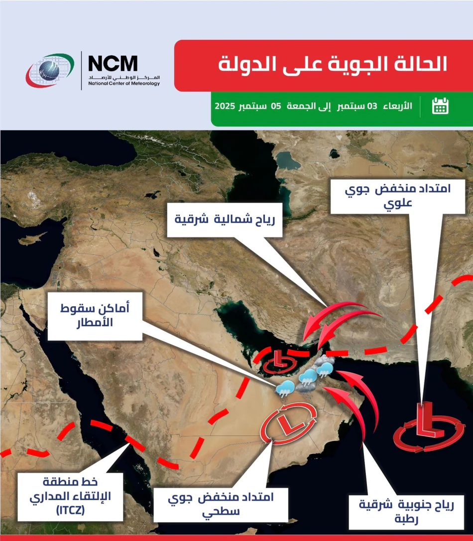
The United Arab Emirates is preparing for a significant weather event as meteorologists predict the convergence of multiple atmospheric systems over the coming days. The National Center of Meteorology has issued warnings for heavy rainfall, thunderstorms, and potential hail across eastern and southern regions, driven by the southward movement of the Intertropical Convergence Zone and moisture-laden air masses from the Arabian Sea.
Weather Systems Create Perfect Storm Conditions
The UAE's weather pattern is being shaped by a complex interaction of meteorological forces. A surface and upper-level low-pressure system extending from the south is combining with the advancing Intertropical Convergence Zone (ITCZ), creating conditions ripe for severe weather. This convergence is particularly significant as it's drawing humid air masses from both the Arabian Sea and the Sea of Oman toward the Emirates.
The eastern mountains are playing a crucial role in this weather development, acting as a catalyst for cumulonimbus cloud formation across scattered areas. This orographic effect—where mountains force air upward, cooling it and triggering condensation—is intensifying the already volatile atmospheric conditions.
Peak Impact Expected Mid-Week
Wednesday and Thursday are forecast to bear the brunt of this weather system. Meteorologists predict the formation of towering cumulonimbus clouds that will deliver rainfall of varying intensities, accompanied by lightning, thunder, and small hailstones. The timing coincides with elevated daytime temperatures, creating additional atmospheric instability.
Regional Weather Patterns and Climate Context
This weather event reflects broader regional climate patterns that affect the Gulf states during transitional seasons. The ITCZ's movement is a natural phenomenon that occurs as seasonal wind patterns shift, but its interaction with local topography and sea-surface temperatures can create particularly intense localized weather.
Similar convergence events have historically brought both benefits and challenges to the UAE. While the rainfall is valuable for the country's water resources and agricultural sectors, the intensity and unpredictability of such systems can disrupt transportation, construction activities, and outdoor events.
Wind and Maritime Conditions
The weather system will generate significant wind activity, with patterns shifting from southeasterly to northeasterly directions. Wind speeds are expected to range from moderate to strong, particularly in association with cumulonimbus cloud development. These conditions will likely stir up dust and sand, reducing horizontal visibility across affected areas.
Maritime conditions in both the Arabian Gulf and the Sea of Oman are forecast to remain relatively calm, with light to moderate wave activity. This suggests that while land-based activities may face disruptions, offshore operations and shipping routes should experience minimal impact.
Implications for Infrastructure and Daily Life
The UAE's modern infrastructure and early warning systems position the country well to handle such weather events. However, the combination of heavy rainfall, strong winds, and reduced visibility typically requires adjustments to transportation schedules, construction timelines, and outdoor activities.
The agricultural sector in the eastern regions may benefit significantly from the rainfall, particularly given the UAE's ongoing efforts to enhance food security through domestic production. The timing of this weather system could provide valuable water resources for both agricultural and groundwater replenishment purposes.


