Powerful Storm 'Irine' Intensifies into Hurricane, Raising Warnings of Dangerous Waves
 Layla Al Mansoori
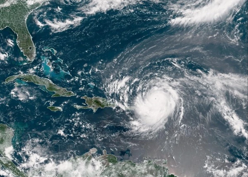
Hurricane Irene Escalates to Category 4, Threatening U.S. East Coast with Catastrophic Storm Surge
Hurricane Irene has intensified into a dangerous Category 4 storm and is poised to unleash life-threatening waves along the U.S. East Coast this week, marking the first major hurricane of the Atlantic season. The storm briefly reached catastrophic Category 5 status before wind speeds subsided, but it remains a formidable threat to millions of Americans from the Carolinas to New England.
Storm Reaches Peak Intensity Before Slight Weakening
Irene's rapid intensification caught meteorologists' attention as it became the season's first hurricane expected to cause significant damage. The storm's brief escalation to Category 5 status—reserved for the most catastrophic hurricanes—demonstrates the explosive power that warm Atlantic waters can fuel during peak hurricane season.
While wind speeds have decreased from their peak, Category 4 hurricanes still pack sustained winds between 130-156 mph, capable of causing devastating damage to infrastructure and posing extreme danger to human life.
East Coast Braces for Multi-State Impact
Storm Surge Emerges as Primary Threat
The most dangerous aspect of Irene may not be its winds but the massive storm surge it will push ahead of its path. Coastal areas from the Outer Banks of North Carolina to Long Island could experience surge heights of 8-12 feet above normal tide levels, potentially inundating low-lying communities and barrier islands.
This surge threat is particularly concerning for densely populated areas like the Chesapeake Bay region, New York Harbor, and coastal New Jersey, where millions of residents live in flood-prone zones that haven't experienced a major hurricane in decades.
Historical Context Amplifies Concerns
The East Coast's vulnerability has grown significantly since the last major hurricane strike. Coastal development has exploded over the past two decades, placing more people and property directly in harm's way. Many residents, particularly in the Northeast, have little experience with hurricane evacuations and preparations.
Hurricane Bob in 1991 was the last significant hurricane to impact New England, while the mid-Atlantic region hasn't seen a major hurricane since Isabel in 2003. This gap has created what experts call "hurricane amnesia"—a dangerous complacency among coastal populations.
Economic and Infrastructure Implications
Irene's projected path threatens some of the nation's most economically vital regions. The storm could disrupt operations at major ports from Norfolk to Boston, potentially impacting global supply chains already strained by pandemic-related disruptions.
The financial sector faces particular scrutiny, as Wall Street and major banking centers lie directly in the storm's potential path. While modern business continuity plans are more robust than in previous decades, a direct hit on New York City could still cause significant market disruptions.
Climate Change Dimension
Irene's rapid intensification fits a troubling pattern that climate scientists have been monitoring. Warmer ocean temperatures provide more energy for hurricanes to strengthen quickly, while rising sea levels amplify storm surge impacts regardless of a hurricane's wind speed.
The combination of increased storm intensity and higher baseline sea levels creates a compounding effect that makes today's hurricanes more dangerous than similar storms from previous generations. This reality forces coastal communities to reconsider evacuation zones and infrastructure resilience that were designed for historical storm patterns.
Preparation and Response Challenges
Emergency managers face the complex task of coordinating evacuations across multiple states with varying levels of hurricane experience. The storm's size means that inland areas hundreds of miles from the coast could experience damaging winds and flooding, expanding the geographic scope of preparation efforts.
Transportation networks represent a critical vulnerability, as millions of potential evacuees must navigate limited evacuation routes. The timing of Irene's approach during a summer weekend could either help by reducing weekday traffic congestion or hinder efforts if tourists and seasonal residents simultaneously attempt to leave coastal areas.


