Powerful Hurricane Irene Threatens the Eastern Seaboard of the United States
 Layla Al Mansoori
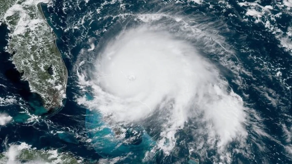
Hurricane Erin Gains Strength as Climate Change Fuels More Intense Atlantic Storm Seasons
Hurricane Erin has rapidly intensified to Category 3 status with winds reaching 127 mph, marking the first major hurricane of the Atlantic season as it barrels toward the Bahamas. While the storm isn't expected to make direct landfall on the U.S. mainland, its trajectory highlights a troubling pattern: climate change is creating conditions for storms to strengthen faster and pose greater threats to coastal economies and infrastructure.
Erin's Current Path and Immediate Threats
The National Hurricane Center upgraded Erin to Category 3 status Monday evening, with the storm generating dangerous ocean currents and waves up to 20 feet high. The hurricane is tracking northward toward the U.S. East Coast and Bermuda, threatening coastal flooding particularly around North Carolina's barrier islands.
Local authorities have issued evacuation orders for vulnerable areas, recognizing that even storms that don't make direct landfall can cause significant damage through storm surge and flooding. The storm has already demonstrated its destructive potential, leaving approximately 150,000 households without power across the Lesser Antilles and Puerto Rico over the weekend.
Economic Impact on Vulnerable Island Communities
The Caribbean islands affected by Erin face a familiar challenge: rebuilding infrastructure repeatedly damaged by increasingly powerful storms. Puerto Rico, still recovering from previous hurricane seasons, represents the economic vulnerability of island territories that depend heavily on consistent power grids for tourism and commerce.
The Climate Change Connection
What makes Erin particularly concerning isn't just its current strength, but how quickly it achieved that power. The storm reached peak intensity within just 24 hours—a phenomenon scientists directly link to rising ocean temperatures caused by climate change.
Warmer oceans act as fuel for hurricanes, providing the energy needed for rapid intensification. This creates a more dangerous scenario for forecasters and emergency managers, who have less time to prepare communities for major impacts.
Comparing Global Storm Trends
The Atlantic isn't alone in experiencing more intense storm activity. The Western Pacific has seen similar patterns with typhoons, while the Indian Ocean has produced stronger cyclones. However, the Atlantic basin's proximity to heavily populated coastlines from Florida to Nova Scotia makes rapid intensification particularly problematic for economic and human safety.
Looking Ahead: A More Active Season Expected
Despite a relatively quiet start, meteorologists predict this Atlantic hurricane season will be more severe than average, extending through late November. This forecast aligns with broader climate patterns that favor storm development, including warmer sea surface temperatures and favorable atmospheric conditions.
The 2024 season already demonstrated this trend's deadly potential. Hurricane Helene claimed over 200 lives across the southeastern United States, serving as a stark reminder that modern infrastructure and emergency response systems still struggle against nature's most powerful storms.
Insurance and Investment Implications
The insurance industry continues adjusting to this new reality, with some companies pulling back from high-risk coastal markets. Property values in vulnerable areas may face long-term pressure as the frequency of major storms increases, while investments in climate-resilient infrastructure become increasingly attractive.
Coastal communities and investors alike must recognize that storms like Erin represent the new normal rather than exceptional events, requiring fundamental changes in how we build, insure, and protect vulnerable areas along hurricane-prone coastlines.


