Powerful Hurricane Irene Batters Northern Caribbean, Triggers Storm Warnings
 Layla Al Mansoori
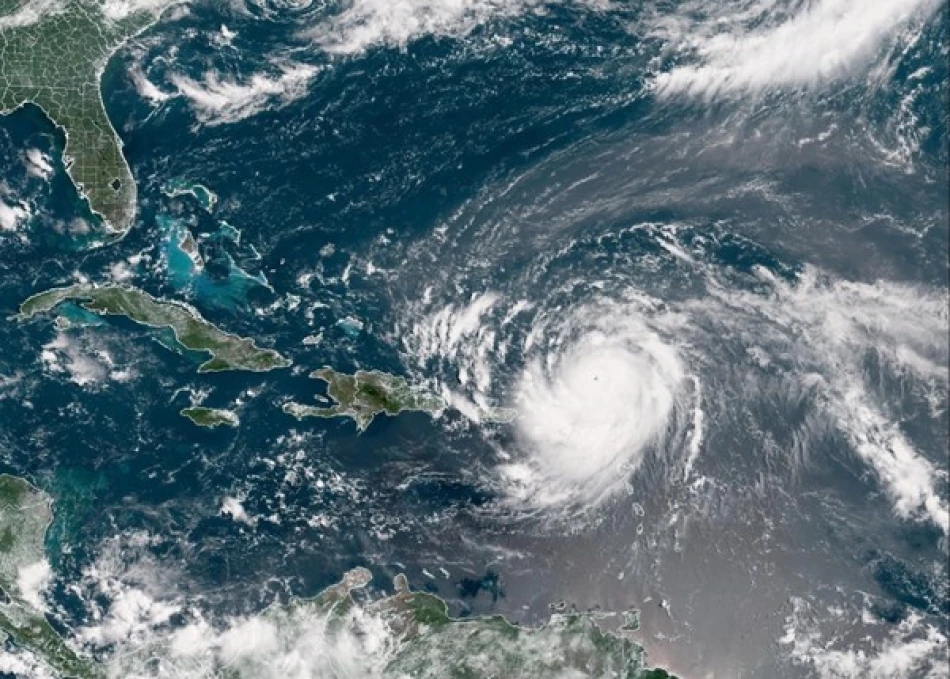
Hurricane Erin Explodes into Category 5 Monster, Threatening Caribbean with Flash Floods
Hurricane Erin has undergone explosive intensification in the Atlantic, transforming from a tropical storm to a Category 5 hurricane in just 24 hours before weakening to Category 4 status. As 2025's first Atlantic hurricane, Erin now packs maximum sustained winds of 240 km/h and poses significant flooding risks to Caribbean islands, even as its center remains offshore.
Rapid Intensification Signals Dangerous Storm Season Ahead
The National Hurricane Center in Miami reported that Erin's center was located approximately 240 kilometers northeast of San Juan, Puerto Rico, moving westward at 24 km/h. The storm's rapid intensification from tropical storm to major hurricane status in a single day demonstrates the kind of explosive development that has become increasingly common in recent hurricane seasons.
This phenomenon, known as rapid intensification, occurs when a hurricane's maximum sustained winds increase by at least 35 mph (56 km/h) within 24 hours. Erin's jump to Category 5 status represents an even more extreme case, suggesting exceptionally favorable atmospheric and oceanic conditions in the Atlantic basin.
Offshore Track Provides Little Relief for Caribbean Islands
While meteorologists expect Erin's center to remain over open waters as it passes north of Puerto Rico, the hurricane's massive size and intensity mean significant impacts are still likely across the region. The National Hurricane Center warns that heavy rainfall could trigger flash flooding and dangerous mudslides across affected islands.
Flooding Remains Primary Threat
Even without a direct landfall, Erin's outer bands are expected to dump substantial rainfall across Puerto Rico and neighboring islands. The mountainous terrain of many Caribbean islands amplifies flood risks, as steep slopes channel rainwater into valleys and urban areas with devastating speed.
Recent hurricanes have demonstrated that indirect impacts can be just as destructive as direct hits. Hurricane Maria in 2017, while making landfall in Puerto Rico, caused catastrophic damage primarily through flooding and infrastructure failures rather than wind damage alone.
Extended Major Hurricane Status Raises Regional Concerns
Forecasters predict Erin will maintain major hurricane status (Category 3 or higher) through late next week, even as it begins a gradual weakening trend. This extended period of intense strength suggests the storm will continue threatening maritime activities and potentially affecting weather patterns across a broad swath of the Atlantic.
Climate Change Fingerprints
Erin's explosive development aligns with climate scientists' predictions about hurricane behavior in a warming world. Warmer ocean temperatures provide more energy for storm intensification, while changing atmospheric patterns can create conditions favorable for rapid strengthening.
The 2024 Atlantic hurricane season was notably active, and early indicators suggest 2025 could follow a similar pattern. Sea surface temperatures in the Atlantic remain well above average, providing the thermal energy that fuels hurricane development and intensification.
Economic and Operational Implications
Major hurricanes like Erin force significant disruptions to shipping lanes, cruise operations, and offshore energy activities in the Atlantic. Even storms that remain at sea can generate dangerous swells and weather conditions that affect ports and coastal operations hundreds of miles away.
For Caribbean tourism-dependent economies still recovering from previous hurricane impacts, even near-miss storms create economic ripple effects through cancelled flights, cruise diversions, and reduced visitor confidence during peak season months.
The early emergence of such an intense hurricane also raises questions about seasonal forecasting accuracy and preparedness timelines. Emergency management officials across the Caribbean and U.S. East Coast will likely reassess their readiness protocols as Erin demonstrates the potential for rapid storm development in 2025.


