Mount Semeru Volcano Erupts in Indonesia, Spewing Ash and Prompting Evacuations
 Layla Al Mansoori
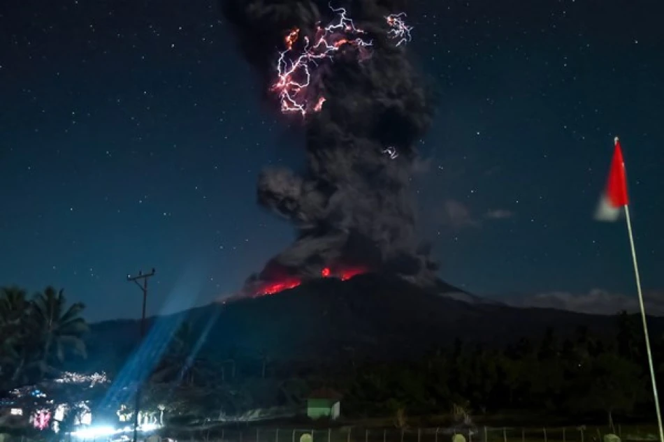
Indonesia's Ring of Fire Awakens: Mount Semeru Erupts Four Times as Volcanic Activity Surges Across Archipelago
Indonesia's volatile geological landscape delivered a stark reminder of its explosive potential Sunday morning as Mount Semeru erupted four times in quick succession, sending ash columns 900 meters skyward. The eruptions come just one day after the catastrophic Lewotobi Laki-Laki volcano blast that hurled debris 18 kilometers into the atmosphere, signaling a concerning pattern of intensified volcanic activity across the world's largest archipelago nation.
Mount Semeru's Latest Display of Power
Mount Semeru, located in East Java province, demonstrated its characteristic explosive behavior with four distinct eruptions throughout Sunday morning. Lisuanto, the official responsible for monitoring the volcano, reported that the ash columns displayed a white to gray coloration with moderate density, drifting toward the southwest.
Despite the dramatic display, authorities have maintained the volcano's alert status at Level II, or "standby" classification. This measured response reflects Indonesia's sophisticated volcanic monitoring system, developed through decades of managing one of the world's most active volcanic regions.
A Weekend of Volcanic Chaos
The Semeru eruptions followed Saturday's devastating blast from Lewotobi Laki-Laki volcano on Flores Island, which launched an ash column reaching an extraordinary 18 kilometers into the sky. This sequence of events within 24 hours underscores the interconnected nature of Indonesia's volcanic system and the constant threat posed by the nation's position along the Pacific Ring of Fire.
The Ring of Fire's Relentless Grip
Indonesia's archipelago of over 17,000 islands sits precariously along the Pacific Ring of Fire, a horseshoe-shaped zone of intense seismic and volcanic activity that circles the Pacific Ocean. This geological positioning makes Indonesia home to approximately 130 active volcanoes—more than any other country—and subjects its 270 million residents to constant seismic threats.
The Ring of Fire accounts for roughly 90% of the world's earthquakes and 75% of its active volcanoes, with Indonesia bearing a disproportionate share of this geological burden. The country's volcanic activity stems from the complex interaction of multiple tectonic plates, including the Indo-Australian, Eurasian, and Pacific plates.
Economic and Social Implications
While volcanic eruptions pose obvious safety risks, they also carry significant economic consequences for Indonesia. The tourism industry, particularly in Java and Bali, faces regular disruptions when volcanic activity intensifies. Mount Semeru, standing as Java's highest peak at 3,676 meters, attracts thousands of hikers and tourists annually, generating substantial local revenue that evaporates during periods of heightened activity.
Agricultural communities surrounding active volcanoes face a double-edged reality: the fertile volcanic soil provides exceptional growing conditions, but eruptions can destroy crops and contaminate water sources. This risk-reward calculation has shaped settlement patterns across Indonesia for centuries, with millions choosing to live in volcanic shadow zones despite the inherent dangers.
Indonesia's Volcanic Preparedness Evolution
The Indonesian government has invested heavily in volcanic monitoring infrastructure following devastating historical eruptions. The 2010 Mount Merapi eruption, which killed over 350 people, catalyzed improvements in early warning systems and evacuation procedures. Today's four-tier alert system represents a significant advancement from earlier decades when volcanic monitoring relied primarily on visual observation.
Modern monitoring combines seismic sensors, gas emission analysis, and satellite imagery to provide comprehensive volcanic surveillance. This technological approach has proven crucial in managing Indonesia's volcanic risks, though the sheer number of active volcanoes continues to strain monitoring resources.
Regional Volcanic Patterns and Climate Impact
The recent surge in Indonesian volcanic activity aligns with broader patterns observed across the Ring of Fire. Similar increases in volcanic activity have been documented in the Philippines, Japan, and Chile over the past year, suggesting possible regional geological triggers.
Large-scale eruptions like Saturday's Lewotobi Laki-Laki event can impact regional air travel and, in extreme cases, global climate patterns. The 1815 eruption of Mount Tambora in Indonesia caused global temperature drops and crop failures worldwide, demonstrating the far-reaching consequences of major volcanic events.
As Indonesia continues to navigate its position along one of Earth's most geologically active zones, the weekend's volcanic activity serves as a reminder that despite technological advances in monitoring and prediction, the fundamental challenge remains unchanged: living in harmony with forces that can reshape landscapes in minutes and affect global systems for years.


