Chilly Weather Ahead: Low-Pressure System to Impact Temperatures from Wednesday to Friday
 Layla Al Mansoori
UAE Braces for Three-Day Weather System Bringing Rain, Thunderstorms, and Dust
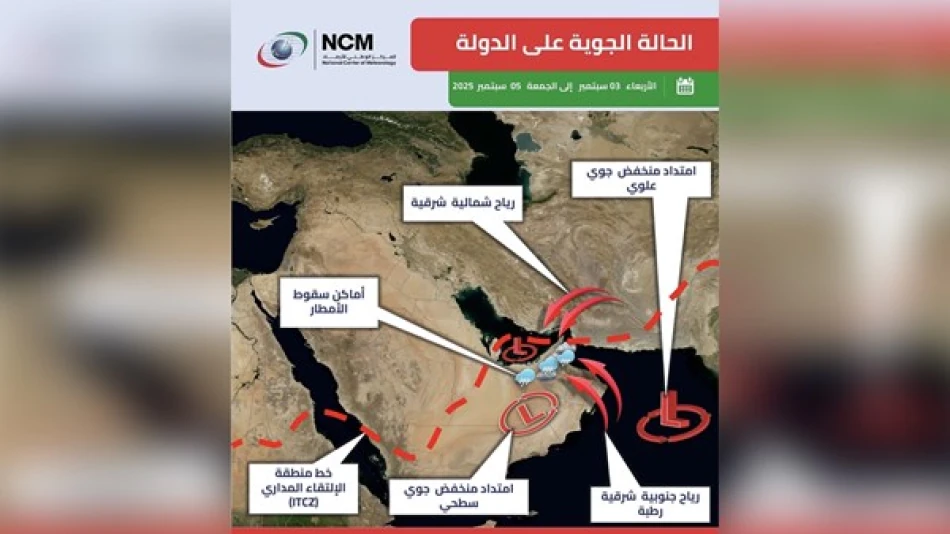
The UAE's National Center of Meteorology has issued weather alerts for Wednesday through Friday, September 3-5, as a surface and upper-level low-pressure system approaches from the south. The weather pattern, driven by the Intertropical Convergence Zone (ITCZ) moving northward, promises to deliver significant rainfall, thunderstorms, and reduced visibility across eastern and southern regions of the country.
Weather System Details and Timeline
The incoming weather disturbance represents a convergence of multiple atmospheric factors that will impact the Emirates over the three-day period. A humid air mass from the Arabian Sea and Sea of Oman is flowing toward the UAE, coinciding with rising daytime temperatures that will fuel convective cloud formation, particularly around the eastern mountain ranges.
The eastern Hajar Mountains will play a crucial role in this weather event, acting as a natural catalyst for cloud development. As the moist air encounters these elevated terrains, it will rise and cool, creating the ideal conditions for cumulonimbus cloud formation.
Expected Impacts by Region
Eastern and southern areas will bear the brunt of the weather system, with activity extending into interior regions. Residents in these zones should prepare for varied intensity rainfall accompanied by lightning and thunder, with the possibility of small hail formation. Wednesday and Thursday are forecast to experience the most intense weather activity.
Wind patterns will shift to southeasterly and northeasterly directions, maintaining moderate speeds but intensifying significantly during thunderstorm activity. These stronger gusts will kick up dust and sand, creating hazardous driving conditions as horizontal visibility drops substantially.
Maritime and Aviation Considerations
Sea conditions in both the Arabian Gulf and Sea of Oman will remain relatively calm, ranging from light to moderate wave activity. This suggests that while land-based activities may face disruptions, maritime operations should experience minimal impact from the weather system.
However, the combination of reduced visibility from dust storms and potential thunderstorm activity could affect aviation schedules, particularly for flights serving the UAE's eastern airports and those crossing affected airspace during peak weather periods.
Seasonal Weather Context
This September weather pattern aligns with the UAE's transitional season, when the country often experiences increased atmospheric instability. The movement of the ITCZ northward is a typical late-summer phenomenon that can bring enhanced rainfall to the Arabian Peninsula, offering relief from the intense summer heat while presenting its own challenges.
The timing is particularly significant as it coincides with the gradual shift away from the peak summer months, when such weather systems become more frequent and can provide valuable precipitation for the water-scarce region. For the UAE's agricultural sectors and water management authorities, these rainfall events represent important contributions to annual precipitation totals.


